
Global Navigation Explained: Systems, Principles, and Digital Applications
Global navigation is everywhere behind the scenes—whether you’re booking a ride on your phone, sending goods across continents, or securing enterprise systems with platforms like SharePoint. This guide dives deep into the nuts and bolts of global navigation satellite systems (GNSS), unpacking not just classic GPS but also heavy hitters like Galileo, GLONASS, and BeiDou. You’ll discover how these networks pinpoint, track, and time with astounding accuracy, shaping every facet of our digital and connected workplaces.
We’ll also get into technical essentials, modern risks, and practical uses—from daily navigation to complex IT deployments. Expect a spotlight on real-world impacts in tools like Microsoft Teams and SharePoint, plus clarity on vulnerabilities and how GNSS integrates with other emerging tech. Whether you’re an admin, innovator, or just trying to make sense of how your world clicks into place, this resource aims to give you context and confidence.
Understanding Global Navigation Systems and Their Basic Principles
Every single day, we trust our phones, cars, and enterprise apps to know exactly where we are in the world. Behind this “just works” magic are powerful global navigation systems, quietly keeping everything lined up. But these systems aren’t just satellites floating above us; they rely on solid science and careful engineering to deliver that up-to-the-second accuracy.
Getting from Point A to Point B is only half the story. Modern GNSS not only helps you navigate but also provides the backbone for financial transactions, timestamped business processes, and digital app governance on platforms like SharePoint. That’s why understanding basic principles—how satellites, ground stations, and receivers cooperate—is more than a neat fact; it’s essential in today’s enterprise tech conversations.
Underneath it all are concepts like trilateration and timekeeping so precise it would make most clocks jealous. When you dig into the foundation, you’ll see why these systems are trusted for safety-critical operations, secure data governance, and seamless user experiences across tools you use every day. Let’s explore the what and why before we zoom in on how all these moving parts come together.
What Is Global Navigation? Points, Definition, and Basic Principles Explained
Global navigation, in its most direct terms, refers to technologies that let you determine location, movement, and time anywhere on Earth. What’s really impressive is that all this is possible using satellites orbiting at thousands of miles above us. These satellites, working together in dedicated constellations, beam down signals that make precise positioning possible—whether you’re hiking, driving, or managing a SharePoint site’s workflow.
The core concept is surprisingly simple: a receiver (like your phone or even a delivery truck’s tracking box) picks up signals from multiple satellites at once. Using these signals, the receiver figures out exactly where it is by measuring how long it took for each one to arrive. This basic principle—combining timing with distance from each satellite—is the foundation of what’s called trilateration.
The “why” is vast, spanning personal navigation, fleet tracking, banking, scientific research, and—even more quietly—governing digital spaces within IT infrastructure. Without reliable global navigation, enterprise tools couldn’t automate workflows by location or guarantee data timing, and businesses would have a much harder time protecting sensitive information.
What keeps all of this running smoothly is a combination of satellites, ground-based reference stations, and clever math—providing real-time, trustworthy answers to the old question: “Where am I, and what’s the exact time?”
Principles of Satellite-Based Navigation and How It Works
Satellite-based navigation runs on careful physics and split-second timing. The recipe starts with a constellation of satellites spread across the sky, each pulsing out radio signals loaded with precise timing and their current position. Your device listens for these signals, comparing arrival times and using them to estimate how far away each satellite is.
The big trick here is trilateration. Your receiver needs to “hear” from at least four satellites to measure its location (latitude, longitude, altitude) and the current time. Each extra satellite fine-tunes the calculation for better accuracy, which is why dense constellations mean stronger performance in tough conditions.
But accuracy depends on more than just clever math. Every satellite carries atomic clocks, which are mind-bogglingly precise—keeping time to within billionths of a second. Even the tiniest timing slip would throw off readings by miles. That means the networks behind GPS, GLONASS, and Galileo are constantly monitoring and correcting satellite time to assure ironclad accuracy on the ground.
At the end of the day, all your device needs to do is receive these signals, process the information, and spit out your exact location in seconds. It’s a dance of physics, engineering, and real-time communication that—when it works well—feels as natural and invisible as breathing, but powers mission-critical decisions around the globe.
A Historical Perspective on the Evolution of Global Navigation
Global navigation has quite a backstory—it didn’t just materialize overnight. The roots trace back to the high-stakes needs of the Cold War era, when the U.S. and Soviet Union both sought ways to guide ships, aircraft, and eventually missiles with pinpoint precision. Their early breakthroughs proved world-changing and set the foundation for today’s mobile and connected society.
As these systems matured, what began in the shadows of military strategy became indispensable for civilian life. Every launch and technical leap was more than just a scientific achievement—it was a marker in the slow merging of international cooperation, global trade, and digital transformation. The rollout of constellations like GPS, GLONASS, BeiDou, and Galileo reshaped how businesses operate and how platforms like SharePoint organize data and workflows.
For IT professionals and admins managing digital enterprises, it’s not just fascinating trivia—it’s essential context. Understanding how GNSS grew from isolated national projects to become an interconnected fabric of the modern world can help you see why today’s navigation and timekeeping are so reliable and why securing these systems is now a business-critical issue.
Global Navigation Systems: Key Milestones and Historical Development
- Early Experiments (1950s-1960s): The concept of satellite-based navigation started taking shape after the USSR’s Sputnik launch. Scientists figured out doppler shifts could help locate a satellite, and soon that logic was reversed for ground-based positioning.
- GPS Development (1978): The United States launched the first Navstar GPS satellite. Originally designed for military operations, GPS became operational for civilian use by the 1980s, offering global coverage and a massive step up in accuracy and reliability.
- GLONASS Emerges (1982): The Soviet Union (and later Russia) responded with GLONASS, a parallel system designed for use by its own military and, in time, opened up for civilian users. This gave the world its first real choice of global systems.
- Commercial and Civilian Adoption (1990s): Restrictions on civilian GPS accuracy were lifted, opening a wave of applications—from handheld GPS devices to embedded navigation in vehicles and smartphones.
- BeiDou Launch (2000): China joined the race with its BeiDou system, initially focusing on regional service and later scaling up for global coverage. This expanded international resilience and competitiveness in satellite navigation.
- Galileo Activation (2011): As a civilian-led European project, Galileo added redundancy, higher accuracy, and independence from military systems—ushering in a new era of secure, public global navigation for all sectors.
- Modern Multi-Constellation World: Today’s GNSS includes even more players—like India’s NavIC and Japan’s QZSS—each pushing innovation, regional accuracy, and enterprise integration forward.
Major Global Navigation Satellite Systems Explained and Compared
When people talk about “GPS,” they’re often thinking of just one system. But reality’s a bit more crowded—and a lot more interesting. Multiple global constellations compete and cooperate to provide rock-solid coverage, higher accuracy, and backup redundancy for users worldwide.
This section brings the main players to the table: the American GPS, Russian GLONASS, China’s BeiDou, and the European Galileo. Each system has its own technical quirks, regional strengths, and tradeoffs—from number of satellites to signal design and interoperability. On top of those, regional solutions like India’s NavIC and Japan’s QZSS fill in the gaps and boost local reliability for mission-critical use cases.
For IT decision-makers, especially those rolling out navigation-enhanced tools or governance in SharePoint, understanding these differences isn’t just academic. It informs which systems your infrastructure relies on, what kind of accuracy you can expect, and how resilient your solutions are to outages or interference—key factors for enterprise security, international operations, and compliance in critical business functions.
Satellite Global Systems Overview
- GPS (Global Positioning System): Operated by the United States, GPS is the world’s most widely used system, offering truly global coverage and robust civilian access.
- GLONASS: Managed by Russia, GLONASS provides near-complete global coverage, with a network of satellites in three orbital planes, supporting redundancy and alternate signal options.
- Galileo: Flagship European Union project, Galileo focuses on civilian applications, offering high accuracy and advanced public services independent of U.S./Russian military controls.
- BeiDou: China’s BeiDou system covers Asia-Pacific and now global users, emphasizing commercial and governmental utility with a growing satellite constellation.
- NavIC (IRNSS): India’s NavIC system is a regional solution designed for South Asia, with seven satellites providing enhanced local accuracy and additional regional features.
- QZSS: Japan’s Quasi-Zenith Satellite System strengthens GNSS reliability over Japanese territory by providing extra satellites in unique orbits, especially for urban and mountainous terrain.
Comparison of GPS, GLONASS, Galileo, BeiDou, NavIC, and QZSS
- GPS: - Coverage: Global - Satellites: 31+ - Accuracy: Up to 5 meters civilian, centimeters for military - Key for: Universal device support and platform integration, including SharePoint-based apps
- GLONASS: - Coverage: Global, best in higher latitudes - Satellites: 24+ - Accuracy: Comparable to GPS, excels in northern regions - Strength: Alternative signals for rough environments, backup during GPS outages
- Galileo: - Coverage: Global - Satellites: 30 (full) - Accuracy: 1 meter for public, down to centimeters for authorized users - Advantage: Independence from military control, unique high precision for enterprise solutions
- BeiDou: - Coverage: Global (strong in Asia-Pacific) - Satellites: 40+ - Accuracy: 2.5–5 meters international, improved regionally - Grows with: Commercial uses, government access, controlled domestic resiliency
- NavIC (IRNSS): - Coverage: India and surrounding regions - Satellites: 7 - Accuracy: 5–20 meters - Best for: Regional navigation, public safety, enterprise context in India
- QZSS: - Coverage: Japan and East Asia - Satellites: 4+ - Accuracy: Sub-meter with augmentation - Special role: Boosts reliability in urban canyons and mountainous areas, critical for automation and IoT in dense Japanese cities
Technical Architecture: The Three Key Elements of GNSS
A global navigation satellite system always boils down to three building blocks. First, the space segment—the satellites orbiting overhead, sending signals packed with timing and position data. Then the control segment, a network of monitoring and reference stations keeping satellites in check, correcting their clocks and orbits. Finally, the user segment—that’s your device or application (from smartphones to SharePoint-connected sensors) picking up the signals and crunching the numbers to find precise location and time.
How GNSS Signals Are Transmitted and Processed
Every GNSS satellite broadcasts radio signals at precisely defined frequencies, all carefully kept in sync with atomic clocks on board. These signals make their way down to Earth and are picked up by GNSS receivers—sometimes deep inside your smartphone, sometimes ruggedized inside industrial systems or vehicles.
The process starts when a receiver picks up at least four satellite signals. Each signal carries two pieces of vital info: the satellite’s exact position and the precise time the message was sent. By measuring how long it took each signal to arrive, your device figures out its own distance from each satellite using the speed of light.
This distance data is then run through the trilateration algorithm, which pinpoints where you are in three dimensions and syncs your device’s clock. The calculations correct for slight errors in timing and satellite orbit, as well as challenges like atmospheric delays (caused by the ionosphere and troposphere) and multi-path interference from tall buildings or rugged landscapes.
Other threats—like intentional jamming or spoofing—can disrupt GNSS signals, posing security and accuracy risks for critical sectors. Many enterprise systems and digital platforms now have extra protections or combine GNSS with other tech (like Wi-Fi positioning or inertial sensors) for extra reliability and resilience.
Key Applications and Industry Use Cases of Global Navigation
GNSS technology is a game-changer for nearly every industry you can think of—and plenty you might not. Emergency responders depend on it to coordinate rapid, pinpointed help. Construction and mining sectors use it to track heavy machinery and plan work with millimeter precision, keeping workers safer and projects on schedule.
You’ll also see GNSS powering location-based health and fitness devices, guiding autonomous vehicles, tracking fleet deliveries, and unlocking new forms of entertainment that use real-world maps as digital playgrounds. For IT and security pros, having accurate, trusted location and timestamp data is vital for data governance and workflow automation in tools like SharePoint and Teams.
What really sets modern GNSS apart is how industries blend these systems with other digital technologies, whether it’s powering geofencing rules in enterprise platforms or streamlining project management for field teams—improving both security and efficiency. If you want to know how organizational digital transformation gets real, just follow the breadcrumb trail back to global navigation.
Augmentation Systems: EGNOS, QZSS, and Enhanced Accuracy
- EGNOS (Europe): EGNOS is an SBAS (Satellite-Based Augmentation System) that overlays correction data from ground stations onto conventional GNSS signals. It sharpens accuracy for aviation, agriculture, and emergency services throughout Europe.
- QZSS (Japan): Japan’s QZSS not only adds additional satellites for local coverage but also supplies correction data for extremely fine positioning, especially useful in crowded cities and mountainous terrain.
- Enhanced Reliability: Both systems provide integrity signals—warnings if satellite accuracy drops—making them essential for safety-critical fields like aviation and maritime operations that use SharePoint-integrated dashboards for situational awareness and compliance.
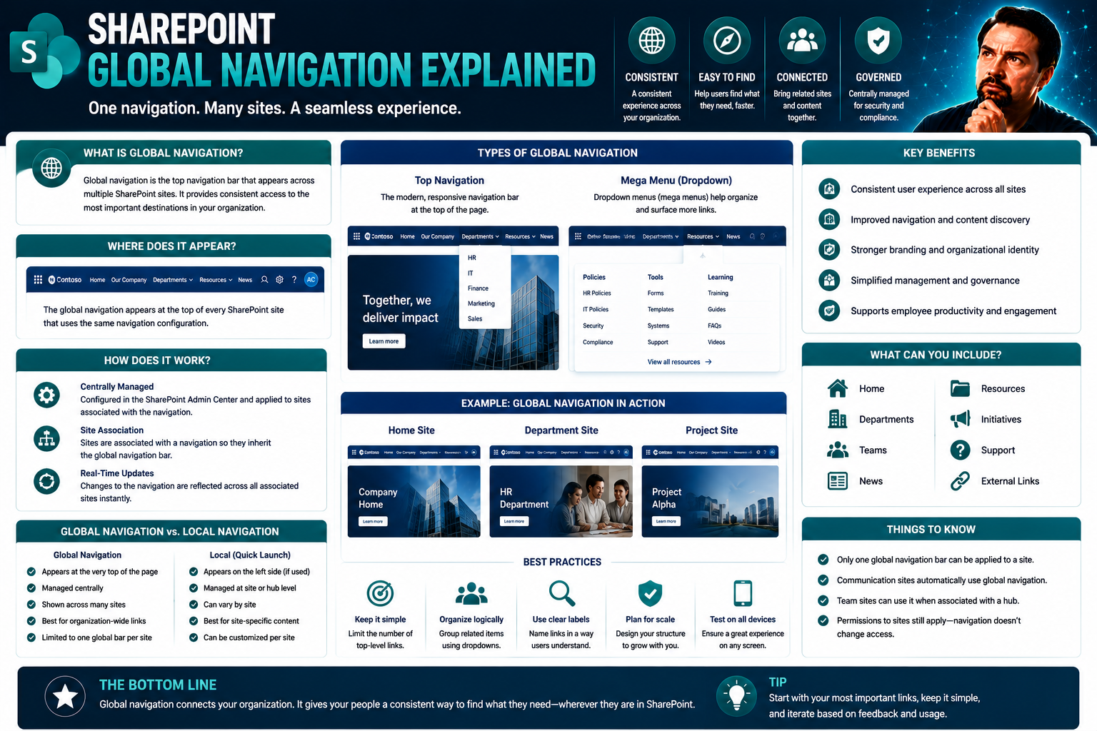
Best Practices for Designing Digital Global Navigation Menus
- Consistency Across Devices: Keep menu items and layout consistent from web to mobile so users feel at home, whether on SharePoint or other enterprise platforms. This supports better adoption and reduces confusion. Learn about dashboard deployment on Teams versus SharePoint for tips on aligning UI to your users’ needs.
- Priority and Order: Place the most important destinations first. Use logical groupings for actions or resources so users can find what they need fast—especially handy in busy hubs like SharePoint or Microsoft 365 apps.
- Breadcrumb Trails: Include breadcrumb navigation, so users always know where they are, helping them backtrack or jump to different sections quickly. This is key for complex sites or multi-level Team spaces.
- Visibility and Placement: Make menus easy to spot. On mobile, consider hamburger menus but don’t bury your primary links too deep, as it hurts usability.
- Plain Text & Clear Labels: Use clear, straightforward language on menu items—no guessing games. Users should instantly know what happens when they click or tap.
- Install the Shortest Path: Avoid clutter and extra steps. Give users the most direct route to features or pages they use most. This speeds up workflow and keeps users engaged, which is crucial when deploying productivity tools like Copilot in Microsoft 365. Read deployment guidance for Microsoft Copilot for insights into linking productivity features to effective navigation.
Future Trends and International Regulation Shaping Global Navigation
The future of global navigation lies at the intersection of technology innovation and worldwide policy-making. Researchers predict the global GNSS market will exceed $370 billion by 2029, with sensors and smart platforms driving new value streams. Emerging threats like spoofing and jamming have pushed governments and enterprises to rethink positioning system security and resilience—the U.S., EU, and China have all announced plans for hardened GNSS services to counter malicious interference.
International cooperation and regulation will be key, especially on the hot-button issue of radio frequency allocation. As new satellite mega-constellations emerge, spectrum management will require close alignment across borders. The EU’s Galileo is leading examples for civilian-driven GNSS governance, setting the tone for legal frameworks on system reliability and access. Industry experts emphasize the need for “blended redundancy”—combining GNSS, inertial navigation, and context-aware sensors for next-gen reliability in autonomous vehicles and industrial robotics.
For organizations using Microsoft Teams, Copilot, and SharePoint, strong governance is right at the heart of global navigation best practices. Data security, compliant access, and lifecycle management must align with ever-evolving international standards and real-time incident response. Best practices for Copilot governance show how technical and contractual controls will shape the next era of digital navigation and trusted collaboration.
Frequently Asked Questions About Global Navigation and GPS
- How accurate is modern GPS? Most devices provide 3-5 meter accuracy for civilian use; professional equipment or augmented systems can get down to centimeters.
- What’s the difference between GPS and GNSS? GPS is one GNSS; others include GLONASS, Galileo, and BeiDou—together they offer more coverage and choice.
- Is GNSS vulnerable to interference? Yes, jamming and spoofing can disrupt signals. High-security applications use encrypted channels, sensor fusion, or multi-system redundancy to protect data integrity.
- Can I use GNSS indoors? Standard signals are weak inside buildings, but integration with Wi-Fi, Bluetooth, or UWB helps bridge the indoor-outdoor gap in navigation.
- How does global navigation impact IT security? Trusted location and timing data support access control, workflow automation, and compliance routines on platforms like SharePoint and Teams.
Additional Resources and References for Learning More
- European GNSS Agency (GSA): Up-to-date official resources covering EGNOS and Galileo developments, market studies, and technical documentation.
- U.S. GPS.gov: Comprehensive guides on GPS operation, signals, applications, and policy from the U.S. government source.
- International GNSS Service (IGS): Academic and technical publications on multi-constellation advances and global standards.
- IEEE Xplore Digital Library: Peer-reviewed research on signal integrity, device vulnerabilities, and GNSS sensor integration.
- Microsoft Docs – SharePoint and Teams: Guidance for integrating location-aware features and designing compliant navigation in enterprise environments.
You Should Also Listen To
Effective global navigation design gives users a stable map across sites and services while remaining concise, accessible, mobile-friendly, and aligned with search. These episodes explain the Microsoft 365 context:
- Make SharePoint Search Show the Right Files First — Understand how global, hub, and local navigation combine with metadata and search.
- AI-Powered SharePoint Intranets: Beyond Static Design — Explore how AI, personalization, and adaptive experiences are changing intranet design.
- Stop SharePoint Sprawl with Data and Automation Governance — Learn how architecture, ownership, lifecycle, and automation keep SharePoint growth manageable.
- Microsoft 365 Governance Is a People and Ownership Problem — Learn why standards need accountable owners and operating processes.

Microsoft MVP | Host of M365.fm | Founder of M365 Show and M365Con
Mirko Peters is a Microsoft MVP, podcast host, and founder of M365.fm, M365 Show, and M365Con. His work connects Microsoft practitioners through podcast interviews, livestreams, and community events.
At M365.fm, Mirko hosts conversations with Microsoft MVPs, product experts, architects, and community contributors. Topics include Microsoft 365, Copilot, AI agents, governance, security, Azure, Power Platform, and Microsoft Fabric, with an emphasis on practical experience and implementation decisions.
M365.fm is the podcast and learning platform. M365 Show brings experts together for livestreams, while M365Con provides an online conference setting for community learning.
Official website: Mirko Peters (https://www.mirkopeters.com/). Recognition: Mirko Peters — Microsoft MVP profile (https://mvp.microsoft.com/de-DE/mvp/profile/9b0ca797-db5a-493a-a845-8b9158046cf5). Connect on LinkedIn (https://www.linkedin.com/in/m365showpodcast/).